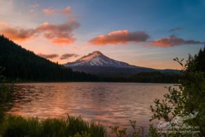
Photographing The Mt Hood National Forest – There are few mountain’s that are more instantly recognizable than Mount Hood. Oregon’s tallest peak, Mount Hood is the second more climbed peak in the world. At 11,249 feet its prominence is seen from all four directions. Located only 50 miles east of Portland Oregon it is easily accessible by two major highways and surrounded by forest and wilderness areas that provide amazing vistas, moss lined creeks and waterfalls. It is also located in the same vicinity as the scenic Columbia River Gorge.
A circuitous route around Mount Hood from Portland can easily be done on an easy day trip. The day includes the Columbia River Gorge and it’s waterfalls, the scenic Hood River Valley and its orchards and sweeping valley views with Mount Hood’s north face clearly in view on a clear day. From Hood River one drives south and up the east flank to the south side of the mountain to the Government Camp area, home of the historic Timberline Lodge and Trillium Lake. From there it’s quick drive the last hour back to Portland.
While in the Mount Hood area, I recommend these must see locations if you plan on photographing the Mt Hood National Forest.
West Side
South Side
North Side
- Lost Lake
- Hood River Valley
- Cloud Cap Inn
- Panorama Point
Washington State Views
- Columbia Hills State Park
- Maryhill / Stonehenge
Gary Randall is a licensed outfitter and guide for the Columbia River Gorge and is authorized by the US Forest Service to conduct tours and workshops there. Gary has lived in and around the gorge all of his life. He knows the area, it’s attractions and its pitfalls. The views and scenic spots to get the ideal photo.
If you choose to tour Mt Hood or The Columbia River Gorge without a guide please use this list as a way to maximize your time on your visit. And please enjoy your stay.
